


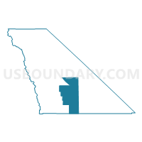
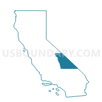
Voting District 50126, Inyo County, California
About
Outline

Summary
| Unique Area Identifier | 531132 |
| Name | Voting District 50126 |
| County | Inyo County |
| State | California |
| Area (square miles) | 940.89 |
| Land Area (square miles) | 930.33 |
| Water Area (square miles) | 10.57 |
| % of Land Area | 98.88 |
| % of Water Area | 1.12 |
| Latitude of the Internal Point | 36.19687140 |
| Longtitude of the Internal Point | -117.23753860 |
Maps

Graphs
Select a template below for downloading or customizing gragh for Voting District 50126, Inyo County, California


Neighbors
Neighoring Voting District (by Name) Neighboring Voting District on the Map
- Voting District 10480, San Bernardino County, CA
- Voting District 50085, Inyo County, CA
- Voting District 50090, Inyo County, CA
- Voting District 50095, Inyo County, CA
- Voting District 50110, Inyo County, CA
- Voting District 50120, Inyo County, CA
- Voting District 50125, Inyo County, CA
Top 10 Neighboring County Subdivision (by Population) Neighboring County Subdivision on the Map
- Lone Pine CCD, Inyo County, CA (2,613)
- Searles Valley CCD, San Bernardino County, CA (2,174)
- Death Valley CCD, Inyo County, CA (765)
Top 10 Neighboring Unified School District (by Population) Neighboring Unified School District on the Map
- Lone Pine Unified School District, CA (2,549)
- Trona Joint Unified School District, CA (1,885)
- Death Valley Unified School District, CA (765)